Digitalization for Natural Territories: When Technology Works for Results
I implement digital solutions that truly solve your operational tasks: from field data collection to analytics for reporting. I adapt technologies to your work specifics.
implementations
reduction
rate
For Those Seeking Practical Digital Solutions That Work in Real Russian Conditions with Limited Resources
Employees fear technology, processes are on paper? I'll implement and adapt digital management systems to your tasks, reducing reporting time multiple times.
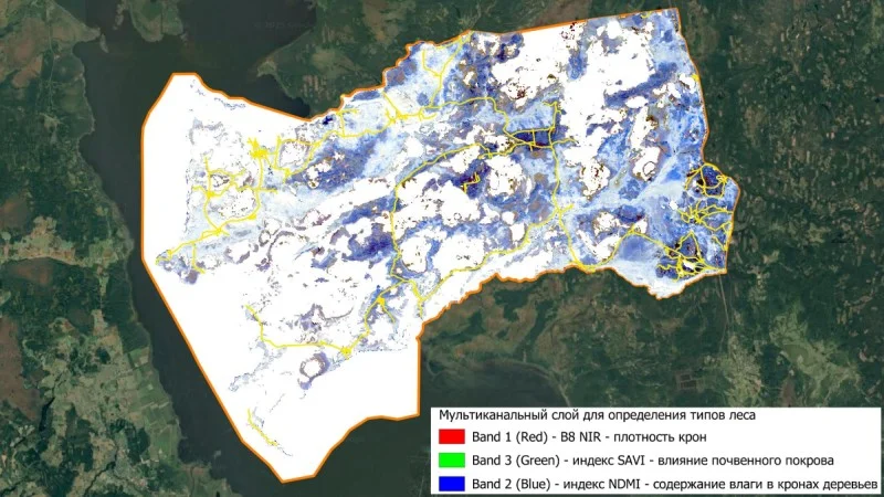
Need environmental monitoring or land use analysis? I'll create specialized digital solutions based on satellite data and GIS.
Need digitalization but no IT specialists or budget? I'll configure SMART and GIS systems for your tasks and train your team to work with them effectively.
Need affordable monitoring tools with limited budget? I'll develop simple mobile apps or adapt existing solutions for your tasks.
Why Does Digitalization for Natural Territories So Often Fail?
Typical problems both government agencies and business face when implementing IT solutions.
Data in Chaos, Decisions on Intuition
All information is scattered across paper journals, Excel files, and personal notebooks. Management doesn't see the real picture on the territory and makes decisions randomly, risking reputation and work effectiveness.
Technology Sits Unused Due to Staff Fear
Employees, especially older generation, fear new systems. They prefer manual work that takes hours instead of minutes, creating a bottleneck for the entire organization.
No Expert Who Understands Both Ecology and IT
In-house IT specialists don't understand conservation task specifics, while ecologists don't know technology. This leads to choosing unsuitable solutions and losing investments.
Ready-Made Solutions Don't Account for Russian Realities
Foreign systems are too expensive and complex for Russian budgets, or don't meet security requirements, while domestic alternatives often don't solve specific conservation or environmental monitoring tasks.
Good news: digitalization works if you adapt technologies to your real tasks and conditions. My experience managing protected areas and deep IT knowledge allow finding solutions where others see a dead end.
Who Can Become a Bridge Between the World of Nature Conservation and the World of IT?
Someone who lived in both worlds. For 12 years I led nature reserves and national parks and know from the inside how data is collected in the field, how reports are written, and where the main "bottlenecks" are. Then I purposefully mastered modern IT tools (GIS, server solutions, mobile development) to automate exactly these processes. I speak both languages.
Why Do I Succeed in Implementing IT Where Others Are Powerless?
Former Protected Area Director
I'm a practitioner. I know the budgetary, staffing, and bureaucratic realities of government institutions. All proposed solutions are initially tested for feasibility in your conditions.
IT for Tasks, Not Vice Versa
I start work by analyzing your specific task (patrolling, bird counting, violation monitoring, or permit issuance) and select or configure a tool for it.
Turnkey Digitalization with Limited Resources
I offer not "expensive solutions for ideal conditions" but working tools for real tasks within your budget. This could be open-source software adaptation, configuring affordable platforms, or developing simple mobile apps — the main thing is that the result is measurable.
Full Cycle: From Idea to Training
I handle the entire process: we discuss the task, select/configure the tool, implement it, train your team (from inspector to research scientist), and provide technical support.
Digitalization Is Not About Technology, It's About Efficiency.
The goal of any IT implementation in protected areas is not to "be modern" but to free up employee time and resources for the main thing: nature conservation and research. When an inspector spends minutes instead of hours on a report, and a scientist sees data on a map instead of in a stack of papers — that's real efficiency.
How Does Digital Tool Implementation Happen?
Transparent Stages Where You Get Results at Each Step
Diagnostics and Task Definition
We thoroughly study which specific operation needs improvement (field data collection, map creation, reporting). We define what result will be success.
Solution Selection and Adaptation
Based on the task, budget and infrastructure, we select a tool (e.g., SMART, QGIS, mobile app, or SaaS platform) and configure it specifically for your needs: creating forms, maps, reports.
Pilot Implementation and Training
We implement the solution for one department or at one site. I conduct training seminars for employees and create simple, clear instructions.
Full-Scale Launch and Support
After a successful pilot, we scale to the entire organization. I provide technical and consulting support during the team's adaptation period.
Format and Timing: I work remotely and with site visits. Timing depends on the task: from SMART configuration (1-2 months) to mobile app development (2-4 months).
How an IT Solution Turned Data Chaos into a Nature Conservation Management Tool
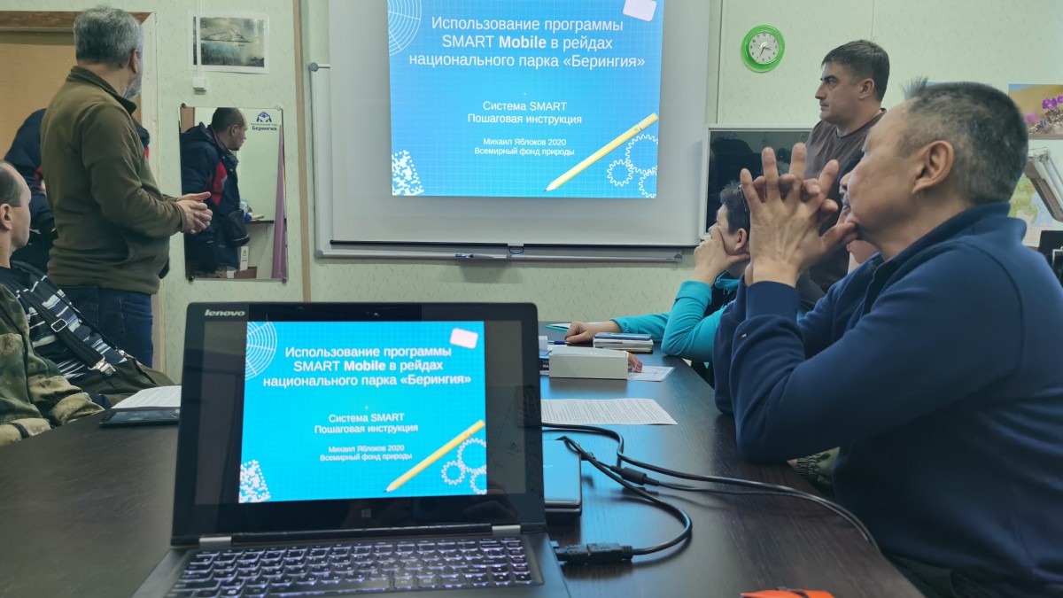
Experience implementing and adapting the SMART system in 6 locations — from national parks to regional hunting departments. Not just software installation, but full configuration for your tasks and team.
Challenge: Before system implementation, work was based on paper and intuition. Inspectors recorded data in notebooks, and the security chief had to spend weeks manually consolidating scattered information for reports. There was no objective picture: where do violations most often occur? Where do rare species concentrate? Are patrols distributed effectively? Management was based on habits, not data. This led to information loss, irrational resource use, and inability to objectively evaluate work effectiveness before management and regulatory bodies.
Solution: I act as a bridge between the world of nature conservation and the world of IT. I select a tool that can solve your specific operational problems with minimal resource costs.
Stage 1: Translating Needs into Digital. Together with the client, I determine: what reports does management and regulatory bodies need? What data should specialists collect in the field to ensure transparency and control?
Stage 2: Adapting SMART to Russian Realities. I configure the database structure, create convenient forms for the mobile app, write scripts for automatic reports. The system learns to speak your language and solve your tasks.
Stage 3: Implementation and "Bringing the System to Life". I install SMART on computers and smartphones, conduct training for employees (often working with smartphones in the field for the first time) and for analysts. Then I support the project for a year so the system becomes part of daily work, not a burden.
Outcome
- ✓ Reports in a Minute. A quarterly violations report that previously took a week is generated with one click.
- ✓ Management Based on Maps and Analytics. Management sees not only patrol routes but also real violation "hot spots", allowing targeted resource distribution and cost reduction.
- ✓ Transparency and Control. All employee actions are recorded with geotags, ensuring discipline, decision objectivity, and protection from regulatory body claims.
- ✓ Unified Digital Space. Data from different departments is collected into one system, becoming the foundation for comprehensive territory management and ESG reporting preparation.
This case proves that digitalization in natural territory management is not about complex technologies for IT specialists. It's about clarity and control for management. SMART implementation through me is a guarantee that the system will work specifically in your conditions, whether it's a federal reserve, hunting enterprise, or extraction company conducting environmental monitoring. You'll receive not software, but a tool for making informed decisions and proving your work effectiveness to any auditors and stakeholders.
Digitalization That Works: From Government Institutions to Business
Real projects in different regions of Russia where digital tool implementation solved operational tasks and reduced routine time multiple times. Each case started with understanding task specifics, not technology selection.
What Changes Does Competent Digitalization Bring?
Concrete Benefits Your Employees and Management Will Feel
Paperwork Routine Reduction
Key data (routes, violations, animal sightings) is immediately recorded digitally in the field. The transcription and rewriting stage from paper journals disappears.
Report Automation and Effectiveness Analysis
The system itself generates reports on completed routes, identified violations, patrol activity. Management receives an objective picture of territory work in the form of maps and dashboards.
Resource Optimization for Planning
GIS analysis allows planning survey or patrol routes with maximum coverage and minimum time and fuel costs, as was done for bird counting in Remdovsky Reserve.
Data Standardization and Quality
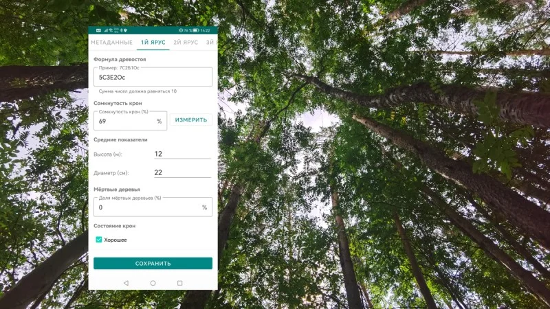
All data is collected in a unified, structured format (as in the Forest Research app). This allows easy analysis, storage, and transfer, excluding errors and information loss.
Honestly about the main thing: Digitalization is a process. It requires initial efforts in training and habit change. But in the end, you receive not just "digital" but a tool for making more informed management decisions and freeing your team's time for meaningful work. I help you go through this path with minimal resistance.
Ready to Discuss
Digitalization of a Specific Task?
Describe what you want to improve: animal counting, inspector work, visitor permit issuance with anthropogenic load control, data analysis, or reporting. I'll study the request and suggest an IT solution that will work in your territory's conditions.
Book a Consultation